Ballymacloon Ringfort, Souterrain and other site features
Ballymacloon is 1.5km east of Quin village. It was the homestead of the McGlúin clan, Baile Mhic Glúin. Following Griffiths Valuation and townland survey in 1855, the English translation was changed from Ballymaclune and it was divided into three separate townlands. The ringfort on the border between West and East Ballymacloon is the highest point in the area at 135’ (41m), allowing for clear views of all surrounding territories. This is considered to be the ‘seat’ of the MacGlúin clan or present day Clune families. The area contains many intact monuments or historical features. According to Conor Clune, in his book ‘The Clunes – From The Dalcassians To Modern Times’, the clan were a prominent family with the Dalcassian sept, subordinate to the MacNamaras under the leadership of the O’Briens.

Within this townland, many different heritage and historic features are still to be found but in this article we will focus on the ringfort and features within it only. More attention needs to be brought to bear on the remainder of these known and unknown monuments, including the possibility of pre-famine dwellings.
Genealogical Tract from Cas to the Clunes, credit Conor F Clune
Ballymacloon Ringfort CL042-043002
The ringfort is a double embankment construction or bivallate with fosse between the embankments. The raised location and double walled embankments suggests the high status of its inhabitants. Most ringforts were constructed between 600 and 900AD, but this ringfort will have to await accurate dating techniques to shed more light on its age.
The ringfort would have offered protection to the inhabitants and the animals on which they depended. While not offering protection against prolonged sieges, its raised location, the proximity to neighbouring ringforts and its double ramparts would have repelled lightning raids that were prevalent in this period.

The first survey of the ringfort arose as part of the OS 6” map series where it appears to be represented as a single wall. Within its confines the surveyor showed a ‘cave’ and a small dwelling. It was later visited by Thomas Westropp in 1901 when a more detailed record of the site and investigation of its past was left to us. He writes of the Ballymacloon ringfort:
“In Ballymacloon East, on a rising ground about half a mile from the last rath, is an even finer specimen. The banks are over 8 feet high, with a deep fosse 16 feet wide, to the south and west, but partly filled at the other points. In the garth, which is 108 feet across, are the foundations of a modern cottage and yards.

From The Proceedings of the Royal Irish Academy – Thomas Westropp 1913 – ‘Types of Ringforts Remaining in East Clare’;
Macan was of Lismacain, near Sodhmacain, or “Macan’s Weir”. Now, the narrative implies that Macan lived close to the mound on Magh Adhair, on some stream. The name “Lismacain” is lost, but, in 1287, there was a “Ballymaking” on the northern edge of the English lands, apparently at or near Ballymacloon, and to the east of Quin. It is quite possible (indeed probable) that the important Liss, with the flooded souterrain, in Ballymacloon, the earthen fort best meeting the above conditions, may be the spot intended; unless (which we have nothing to show) the actual (as apart from the supposed) Norman territory, lay across the river, when the Liss may have been Creevagh. The only Liss name within the river-loop is Ballylassa, in quite the other direction.
Ballymacloon ring fort is located on the edge of the townland boundary between east and west at the highest point in the locality. The inner ringfort is 33m in diameter, according to TJ Westropp. This is difficult to confirm currently as it is over-grown with very rough terrain but measurements taken of other aspects of the ringfort suggest this is correct. Within the ringfort is the footprint, with rising walls of various heights, not exceeding 1m, of the modern dwelling and yard referred to above, as well as the entrance to the souterrain.
The inner embankment rises to 3m in most places and remains broadly intact. This is separated by a 9.7m (Westropp records 4.8m) wide fosse from the outer embankment. This is clearly discernible for most of its circumference by the embankment and ridge but is only marked on the north-east by the ring of trees. The trees on the ridge and within the ringfort are mostly hazel, with the occasional blackthorn.
Cottage and Yards
The 1842 6” map shows a building within the confines of the ringfort. Westropp described it in 1901 as a “modern cottage and yards”. While not common, it was not unusual to find homes of more recent vintage built within ringforts. Thatched cottages have been recorded at various ringfort locations in Ireland. No record can be found to identify the families that lived within Ballymacloon ringfort, but we can reasonably assume they were descendants of the McGlúin clan.
The footprint of the dwelling or yards is still clearly visible in the form of rising walls (to a max of 1m), cornerstones and collapsed stone rubble. The overall footprint is 16.3 by 6m. It is not possible to determine the extent of the dwelling house from that of the house and yards. These walls are roughly 0.5m thick.
The entrance to the souterrain is 1.5m in front of the outside of the above footprint. Measurements taken within and above the souterrain indicate that the back wall of the main chamber is directly below the back wall of this footprint, which is built into the inner embankment. This may have no significance and be purely coincidental.
The remains of a pathway climbs the inner embankment and leads to the north east corner of this footprint. This may have led into a yard that fronted the dwelling house, but this is speculation only.
The ringfort is not large in comparison to others found in Ireland but the ‘modern’ construction just described takes in almost half its area. It is too large to have been only a dwelling so Westropp’s record makes some sense. The hatched representation of the building shown in the 1842 OS map suggests it was roofed at the time of the site visit. Further investigation is warranted.
Souterrain CL042-043002
Souterrain (from French sous terrain, meaning “sub-terrain”), is a name given by archaeologists to a type of underground structure associated mainly with the Iron and early medieval ages (600 – 1000AD).
Souterrains are underground galleries and in their early stages, were always associated with a settlement. The galleries were dug out and then lined with stone slabs or wood before being reburied. They do not appear to have been used for burial and it has been suggested that they were food stores or hiding places during times of strife, although some of them would have had very obvious entrances. Artifacts found in some souterrains have led to the possibility of ritual use also.
Souterrains are usually referred to in Ireland simply as ‘caves’ on early OS maps. A. T. Lucas, a folklorist and director of the National Museum of Ireland in the 1960s, published a series of articles on the references to souterrains in the early Irish annals.
In Ireland, souterrains often are found inside or in close proximity to a ringfort and as such are thought to be mainly contemporary with them. This belief is reinforced by many examples where ogham stones dating to around the 6th century have been reused as roofing lintels or door posts (e.g. at the widened natural limestone fissure at the ‘Cave of the Cats’ in Rathcrogan). The distribution of souterrains is now evenly found throughout the country. Clare is well represented in this distribution and the area around Quin is particularly so, due to the wide number of ringforts here.
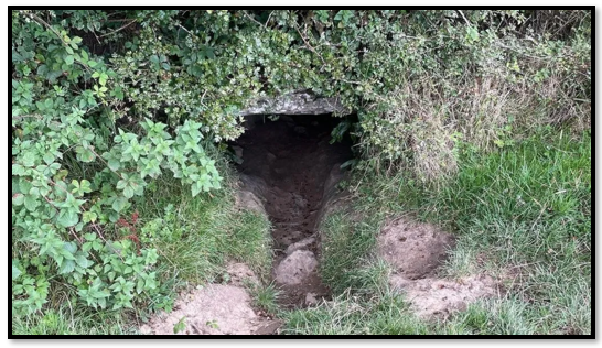
Besides Ballymacloon East, souterrains can be found locally at Ballykilty, Cutteen, Kildrum, Keevagh and Creevagh. They are all located within a ringfort site. The feature we are focussing on here is the best preserved that we are aware of in the locality, probably due to its functional use as a well up to when the water networks were constructed, more detail of which we will discuss below.

The Ballymacloon souterrain is a T-shaped construction. It appears to have been water-logged since at least 1901 when Westropp visited. This is likely to be a collection of overhead rainwater from above ground as the site is too high for a natural well or stream. The formation of small stalactites underneath the lintels would support this. The visitor must step into water immediately upon entry.
Within living memory, entrance steps and supporting side walls were in place to aid entry. The side walls appear to have collapsed into the entrance disguising or perhaps destroying the steps, some remnants still remain. Entry is now through a cave-like opening roughly 0.8m square reached via a steep incline. The souterrain is oriented 60/240 degrees (ENE-WSW) from the entrance. The main chamber is 8.4m in length and tapers in its width from 1.3m at the entrance to 2m at the opposite end. The floor drops as you proceed along the chamber so the water depth increases, but offers a bit more standing space as a result. The walls, made mostly of medium sized stones, lean from floor to ceiling. The lean is more acute at the entrance end of this chamber. Corbel stones at the top of the walls support a series of lintel stones in the roof.

The second chamber, at right angles to the first chamber, is 6.7m in length. The walls do not lean as much as in the main chamber and it presents a more regular rectangular profile. The water depth at the back of this is at its deepest, being 0.6m during our visit, but this will be subject to seasonal change. The width changes from 1.1m on entry to almost 2m at its far end.
“Creeps, which are structures built to impede movement within the souterrain, are typically found between chambers, between passage and chamber, subdividing a passage or at the entrance. They are usually of the ‘simple’ variety, a short, lintelled tunnel less than one metre square” according to Richard Warner in ‘Irish Souterrains-Later Iron Age Refuges’. The narrow entry to the second chamber appears to perform the function of restricting entry in the manner described above.
Thomas Westropp visited the site in 1901 and leaves us the following written record:
“Below this (the ringfort), in a pit about 6 feet deep, is the ope of a southerrain or “cave.” The place was described to me by a farmer as “full of water and badgers,” and was habitually too flooded to be easily explored, though the “Irish bear” was not visible. Its sides, as usual, were of small stones, and sloped from 4 feet 4 inches at the floor to 2 feet 7 inches at the roof, being about 5½ feet high. The entrance has two strong lintels about it, each a foot thick. The passage at the sixth lintel inward is 6½ feet wide. At 12 feet inwards we find a side chamber to the south, 4 feet wide and high, too flooded to explore. Its entrance lintel bears up the seventh and eighth covers of the main passage; so it is part of the original plan. Beyond are several more lintels, and an end-wall of small stones. There are no scribings visible on the lintels of this and other similar “caves,” and the rath is nameless.’
Well or Souterrain?
This feature has variously been described as a well or a souterrain. Its finely preserved entrance with support walls and steps, up to the 1980’s, leading to a reliable supply of clear water, led to its description locally as Ballymacloon Well. Locals can still remember collecting water there before the provision of supply to homes. A pipe attached to a pump supplied one nearby home with grey water for toilets and other uses.

The Quin Heritage group is very grateful to Pat Ryan for bringing attention to this unusual souterrain and to the landowner, Michael Keane, for giving permission to enter his land to visit the fort.
Please note: The Ballymacloon ringfort is on private land and cannot be entered without permission. The souterrain constantly holds water, the ground under foot is uneven. The water levels rise substantially in winter so visiting the site may be dangerous.
References and recommended reading
The Clunes-From the Dalcassians to Modern Times, by Conor F Clune
The Irish Ringfort, by Matthew Stout