County Clare’s Bullaun Stones
Depending on what you consult, there are between 50 (National Monuments Services, 2026) and 54 bullaun stones in County Clare (David McGuinness – 2025 update of original 2006 paper). Added to this, McGuinness has identified 15 more stones in need of inspection and classification. In the whole of Ireland about 1,000 stones have been identified as possible bullauns.
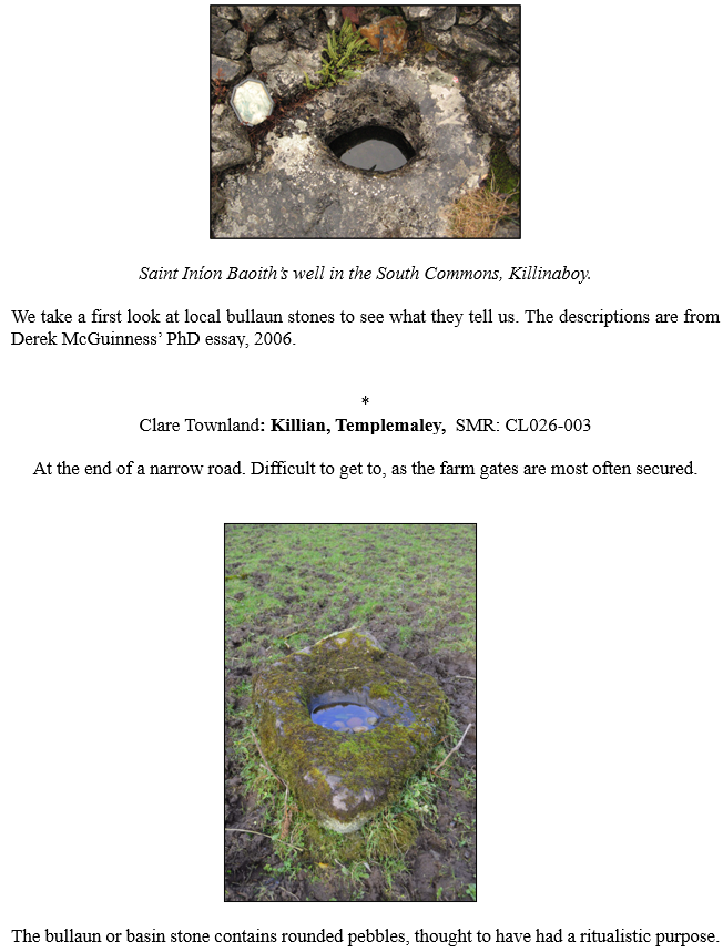
So, what is a bullaun Stone? By definition ‘The term bullaun/bullán is used by archaeologists to describe man-made hollows or basins cut into outcropping rock, boulders or small portable stones. One, two or more hollows may occur in a stone. Bullaun stones are mostly found in association with ecclesiastical enclosures, penitential stations, holy wells and burial grounds and sometimes with ringforts.’[1]
In Dinneen’s 1904 dictionary, the word is given as ‘bullán, -áin, pl. id., m., a round hollow in a stone, a bowl’. The term bullaun is well established in Irish archaeology for a range of ‘man-made hollows or basins cut into outcropping rock, boulders or small portable stones’ (Dolan 2013).
The bowls/bullauns are most often on one side of the stone only, usually the upper surface. A smaller number of stones are double-sided, and a few have several depressions, side-by-side. Most of these hollows are not very deep, going to a maximum depth of approx. 25 cm. They are mostly circular or subcircular and are socket-like, able to facilitate a smooth stone, that they may have once contained.
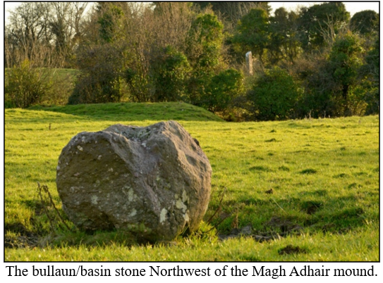
Bullauns are thought to have been initially mortars used in food production and/or metallurgy (Hamlin 2008; Dolan 2013). However, this clarification is not enough to explain all the various types and locations. For example, free-standing and rock-cut bullauns are noted at several Irish inauguration sites, suggesting a ritual function. This includes the fine bullaun stone at the forefront of the Magh Adhair inauguration mound in Toonagh townland.
People point to the significant number of bullauns located at or near old churches or ecclesiastical centres to suggest a spiritual or sacred context. However, it must be remembered that earlier churches were in essence the earliest proto towns. The large churches drew craftsman and traders of many kinds to the church vicinity. The humps and bumps in the green leading into Quin Abbey may have been buildings, for clerical students. Alternatively, they might be the remains of skilled labourers’ cottages, engaged in the construction of the friary – a craftsmen’s village
Many bullaun stones, when filled with rainwater became ‘wart wells’. They were frequently visited for help with a cure. Perhaps the stillness of the basin water made it appropriate as a potential treatment in the cure of warts. There was also a theory that traces of minerals leached from the stones into the rainwater helped in the removal of warts.
[1] Irish Inventory Record
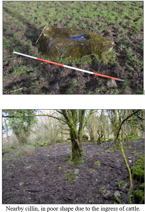
Cl. 32 (S) Fig. 74 County: Clare Townland: Killian SMR: CL026-003 NGR: 13638, 18566 Stone Type: Sandstone Bas. no.: 2 L.: 161cm W.: 106cm H.: 46cm Dm.: a) 52cm x 42cm Dp.: a) 15cm b) c. 27cm x c. 25cm b) c. 2.5cm Dp. (low rim): a) 14.5cm Dp. (high rim): a) 15.5cm b) nr b) nr Dist. bas. st. edge: a) 16cm Dist. bass.: c. 5cm b) 16cm
Description: Large kite-shaped boulder, apparently not embedded in the ground but accepted as in situ due to its size and its location on this spot for over a century. To E of centre of flattish upper surface of stone is a large oval or roughly sub rectangular basin (a); to W of this is a shallow roughly circular depression (b) which clearly represents the beginnings of a second basin. Basin (a) has section with steep side diametrically opposed to shallow side; steep side of section runs from E clockwise to S, in the vicinity of that part of basin closest to edge of stone; the shallowest side of the basin is to W, farthest away from edge of stone. The impression that this somewhat asymmetric version of this common type of section gives is much clearer when basin is viewed as a whole than in either of the sections recorded here. Basin (a) is ground quite smoothly but is irregularly shaped due to character of stone; rim is quite poorly defined. Basin (b) is somewhat coarse textured with very poorly defined rim. Basin (a) contains six small water-rolled pebbles; there were formerly nine.
Context: The stone is located in South quadrant of large, oval stone-walled enclosure (c. 90m x c. 75m), near the surrounding vallum. At centre of enclosure is an enclosed cillín; a church is supposed to have existed on the site and may be represented by a building noted by Lenihan at N side of the cillín enclosure. There is a cashel (CL026-003) c. 25m to NE of enclosure (Frost 1893, 47; MacMahon 1984; Lenihan 1994, 44; SMR).
Folklore: The stone was known as ‘Doughnambraher Font’, ‘Jack Baker’s well’ and the ‘Wart Stone’. The small, rounded stones within the larger basin, and apparently also the water collected in it, are used to cure warts and possibly sore eyes. Crozier and Rea state that the stones were turned in order to make the cure, but this conflicts with Lenihan’s account given below and is clearly based on a misunderstanding of Stacpoole, who represents their sole source of information on this stone: Stacpoole merely suggests that the stones might have been turned as part of the cure. Numerous coins of varying denomination found in the basin by the writer (9/5/00) presumably represent offerings associated with the curative ritual. Lenihan describes rounds that were carried out at the site by those seeking cures: ‘The round consists of three visits, on Monday-Thursday-Monday or Thursday-Monday-Thursday. On each visit kneel at the stone, rub each of the round stones to the afflicted part, saying one Pater and one Ave each time and then making the Sign of the Cross. Some item—money, a medal or whatever—should be left under the bullaun-stone at the completion of the visit’. It is believed that three saints or three murdered friars are buried beneath the bullaun-stone. The water in the bullaun supposedly never dries up, even in the hottest summer.
References: ?O’Donovan et al. 1839b, 127; Frost 1893, 47; Stacpoole 1904*; Westropp 1904a*; 1907a, 471*; 1917a, 9*; Crozier and Rea 1940, 107*; Price 1959, 167, Pl. XIII, 4*; MacMahon 1984*; Spellissy and O’Brien 1987, 24*; Lenihan 1994, 43-4, Pl. p. 44*; SMR*
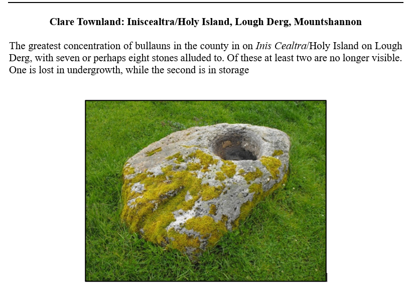
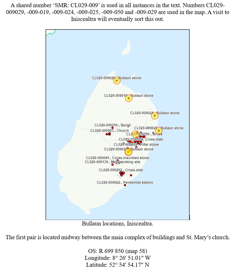
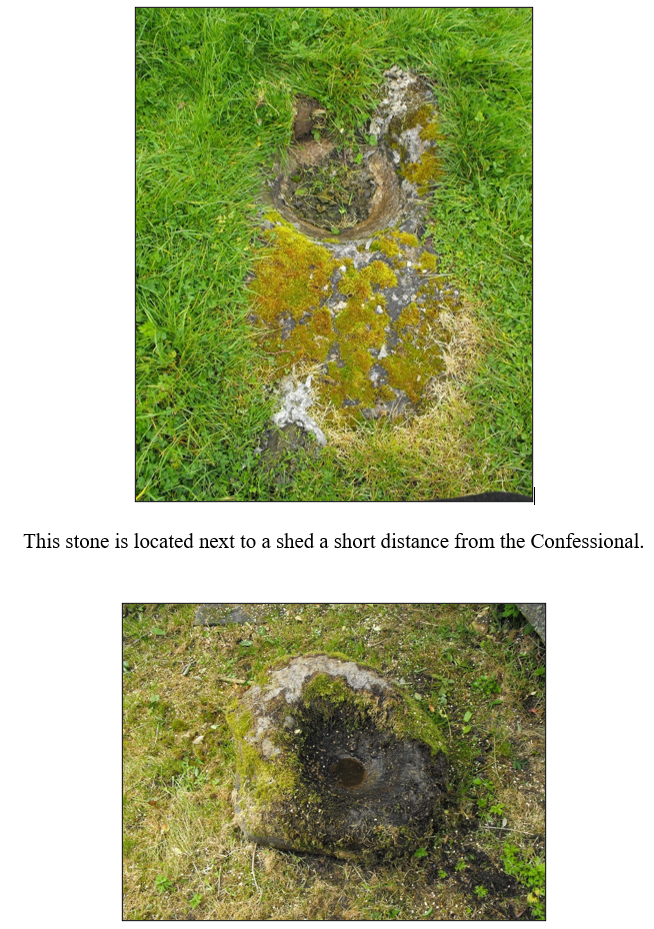
Description: Situated c. 30m N of St. Caimin’s Church (CL019-009011-) on Inis Cealtra and obscured by wooden fencing. A small subcircular stone (L 0.6m; Wth 0.56m; H 0.3m), almost totally moss-covered with a circular basin (diam. 0.35m; D 0.18m) filled with clay. This bullaun may have moved to different locations on the island at various stages. Dunraven (1877, 56) placed it at the W gable of St. Caimin’s church and in 1984 it was noted at the North gable (McNamara 1984, 32, no. 3). McNamara also noted a ’round blue sandstone’ weighing 5kg in the basin which is no longer present.
The fourth stone is in the water. Follow the path to the lake from the Confessional and along the shore to the left. You should see the stone a few meters out.
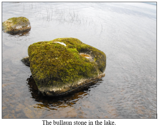
OS: R 700 851 (map 58)
Longitude: 8° 26′ 45.69″ W
Latitude: 52° 54′ 57.42″ N
SMR: CL029-009 Stone Type: Sandstone L.: c. 69.5cm Dm.: 38cm x 35cm Dp. (low rim): Dist. bas. st. edge: c. 6cm Fig. 75(i) NGR: 16990, 18502
Bas. no.: 1 W.: c. 62cm na Dp.: 15.5cm T.: c. 30cm (max. vis.) Dp. (high rim): na Dist. bass.: — 301
Description: Small irregularly shaped boulder, lying loose on ground and no longer in situ (see context below). In flattish upper surface, which currently slopes down to WSW, is a single oval basin with rounded conical section. Stone has been surveyed as if upper surface were approximately level, as it may originally have been. Basin has slight version of section with steep side diametrically opposed to shallow side; steep side of section is to NNW. There is a break in slope more than halfway down the NW side of the basin, at which point the slope gets shallower. Basin is regularly carved and its lower part is ground quite smoothly; its upper part is coarse-textured.
Context: The stone lies loose with other stones in a fenced area beside a wooden OPW hut, having formerly stood to one side of W doorway of the nearby St. Caimín’s church at EC monastery of Holy Island or Iniscealtra.
SMR: CL029-009 Stone Type: Sandstone conglomerate L.: 187cm Dm.: 49cm x 45cm Dp. (low rim): Dist. bas. st. edge: 22cm Fig. 72 NGR: 16985, 18495 Bas. no.: 1 W.: 110cm na Dp.: 22cm T.: c. 51cm (max. vis.) Dp. (high rim): na Dist. bass.:
Description: Low irregularly shaped earth fast boulder with single, very large, roughly D-shaped basin to SW of centre of upper surface; stone was moved during excavation and is no longer in situ (see Context below). Basin has section with steep side diametrically opposed to shallow side; steep side of section is to SW, where it is much closer to edge of stone than shallow side. Basin is ground quite smoothly despite rugged character of stone; rim is irregular due to nature of stone, but quite well-defined. Several thick patches of what appears to be mortar adhere to N, E and S sides of basin. Context: Stone lies c. 24m to SW of round tower at EC monastery of Holy Island or Iniscealtra (Fig. 7.4), which is described at beginning of catalogue for Co. Clare. Excavations around the bullaun in the 1970s uncovered a second bullaun stone (Cl. 25) just over 1m to S (it currently lies c. 70cm to SW), and—in disturbed soil with charcoal flecks and burnt material—a number of stone-filled pits, post holes, the remains of a ‘cow burial’, burnt bone, whetstones, nails, clay pipe fragments, roofing slates, mortar, and a quantity of cupric slag; also found was a stone pestle, ‘possibly to fit into the hollows of the bullaun stones’. There was some slag and bones in the charcoal-flecked soil underneath both bullaun stones. De Paor suggests that this and other similar activity S and W of the round tower dates to the 12th and 13th centuries. About 5m to NE was a circular house, c. 10m in diameter, dated by a coin hoard deposited under its central hearth to the late 12th century.
Six other bullaun stones are associated with the monastery (Cl. 23, 26-30) (Macalister 1917, 143 (No. 2); MacNamara 1984, 32 (No. 2); de Paor 1997, 89-91, Fig. 35).
SMR: CL029-009 Stone Type: Sandstone conglomerate L.: 170cm (max. vis.) Dm.: 55cm x 48cm Dp. (low rim): Dist. bas. st. edge: na Fig. 73 NGR: 16985, 18495 Bas. no.: 1 W.: 88cm (max. vis.) Dp.: 18cm na T.: c. 20cm (max. vis.) Dp. (high rim): na Dist. bass.:
Description: Earth fast boulder embedded in ground, with flattish upper surface flush with ground level and partly obscured by grass; stone was moved during excavation and is no longer in situ (see Context below). At NNW end of visible part of upper surface is a single, enormous roughly D-shaped basin. The NW part of basin seems to have broken away but this appears not to affect measurements or sections. Basin has slight version of section with steep side diametrically opposed to shallow side; ‘steep’ side of section is to ESE. Basin is irregularly ground and very coarse-textured, due at least in part to rugged character of stone; rim is somewhat poorly defined on NE side and well-defined elsewhere. Context: Stone lies to SW of round tower and c. 70cm to SW of a second bullaun stone (Cl. 24) at the EC monastery of Holy Island or Iniscealtra (Fig. 7.4), which is described at beginning of catalogue for Co. Clare. Stone was uncovered during excavations in the 1970s just over 1m to S of the second stone. 302 Excavations around both stones uncovered—in disturbed soil with charcoal flecks and burnt material—a number of stone-filled pits, post holes, the remains of a ‘cow burial’, burnt bone, whetstones, nails, clay pipe fragments, roofing slates, mortar, and a quantity of cupric slag; also found was a stone pestle, ‘possibly to fit into the hollows of the bullaun stones’. There was some slag and bones in the charcoal flecked soil underneath both bullaun stones. De Paor suggests that this and other similar activity S and W of the round tower dates to the 12th and 13th centuries. About 5m to NE was a circular house, c. 10m in diameter, dated by a coin hoard deposited under its central hearth to the late 12th century. Six other bullaun stones are associated with the monastery (Cl. 23, 26-30)
SMR: CL029-009 Stone Type: nap L.: (Macalister) 5’ 6” (165cm) Dm.: (Macalister) 15″ (37.5cm) NGR: 16997, 18505 Bas. no.: 1 W.: 3’ 5” (102.5cm) T.: 2’ 9” (82.5cm) Dp.: 6″ (15cm)
Description: Macalister describes this as ‘a boulder 5 feet 6 inches by 3 feet 5 inches, 2 feet 9 inches high, with a cup-hollow 1 foot 3 inches across, and 6 inches deep’. McNamara writes of what appears to be the same stone that it is the largest bullaun stone on the island and that ‘it has the basin similarly placed as in No. 1 [Cl. 25] and No. 2 [Cl. 24]’, that is away from centre of stone.
Context: According to Macalister, stone lies on E shore of Holy Island ‘about 25 yards north of the landing-stage’ (Fig. 7.4); close by to W is an EC monastery, which is described at beginning of catalogue for Co. Clare. This appears to be the stone which, since the Electricity Supply Board raised the level of Lough Derg, has been surrounded by water c. 10m from the shore; the writer could see it from the shore but was not able to examine it properly. Seven other bullaun stones are associated with the monastery
SMR: CL029-009 Stone Type: nap Dm.: (Macalister) 16″ (40cm) NGR: 16997, 18505 Bas. no.: 1 Dp.: 9″ (22.5cm)
Description: Macalister describes this as ‘a boulder 2 feet 5 inches by 1 foot 5 inches by 1 foot, with a broken hollow, 1 foot 4 inches across and 9 inches deep’. During a brief examination, the breakage referred to by Macalister was seen by the writer to comprise a narrow crack in the stone running right through the basin, which is located in flattish upper surface of stone. Stone would appear to be in situ. Context: According to Macalister, stone lies ‘a short distance north’ of previous bullaun stone (Cl. 26) at the early Christian monastery of Holy Island/Iniscealtra. Six other bullaun stones are associated with the monastery
SMR: CL029-009 Stone Type: nap L.: (Macalister) 2’ 7” (77.5cm) Dm.: (Macalister) 17″ (42.5cm) NGR: 16983, 18530 Bas. no.: 1 W.: 1’ 9” (52.5cm) T.: 1’ 5” (42.5cm) Dp.: 5″ (12.5cm)
Description: Macalister describes this as ‘a stone 2 feet 7 inches by 1 foot 9 inches by 1 foot 5 inches, with an oval depression measuring 1 foot 5 inches by 1 foot, and 5 inches deep’. Context: According to Macalister, stone lies ‘near the shore towards the north’ of Holy Island (Fig. 7.4), on E side of which is an EC monastery described at beginning of catalogue for Co. Clare. This is probably the stone marked on the map on the ASI website c. 40m to NNW of another bullaun stone (Cl. 29) and c. 43m to NE of an old roadway running from monastery to N shore of island. Six other bullaun stones are associated with the monastery (Cl. 23-27, 30) (Macalister 1917, 143 (No. 5); SMR). References: Macalister 1917, 143 (No. 5), Pl. VII*; ?Evans 1966, 70*; Madden 1990b, 28, Fig. p. 18*; SMR*
SMR: CL029-009 Stone Type: Sandstone conglomerate L.: 86cm Dm.: na Dp. (low rim): Dist. bas. st. edge: na W.: c. 76cm na NGR: 16987, 18512 Bas. no.: 1 T.: c. 28cm (max. vis.) Dp.: na Dp. (high rim): na Dist. bass.
Description: Fragment of a roughly rounded boulder containing just over half of a very large oval basin in flattish upper surface; the intact E edge of stone roughly follows line of basin. Stone appears to lie loose and cannot, in view of the extensive breakage, be accepted as in situ; in any case it is impossible to record standard measurements for basin, and it can only be said that maximum visible diameter is 50cm and maximum visible depth is 20cm. Basin is somewhat coarse-textured; the surviving part of rim is irregular due to consistency of stone, but reasonably well-defined. This stone is almost certainly that for which Macalister quotes a description by a Mr. Hibbert dated 1915: ‘The stone is sandstone, with occasional small, rounded, quartz pebbles in it; undoubtedly it has been shaped [to a hexagonal form]. The flat faces and angles are too clean and sharp not to have been worked. There is a lump on one of the angles which is the only portion not cut away. The bottom is shouldered off all round, so far as I could feel’; Macalister adds: ‘From a sketch with dimensions, in Mr. Hibbert’s letter, it appears that the hollow is 18 inches [c. 45cm] across, and 8.5 inches [c. 21cm] deep; the margin round the hollow is of a maximum breadth of 7 inches. The hollow is of the usual rounded form, not following the hexagonal outline of the stone itself’. In addition to similarities in stone type and in the size ratio between stone and basin, the dimensions of the basin are similar to those estimated by the writer; the fact that Hibbert does not mention the breakage might indicate that it had not yet taken place. The identity of the two stones is further suggested by the similarity in their location (see below) and the fact that no other stone is visible in this part of the island. Context: Stone lies c. 43m to ENE of an ancient roadway which runs NNW from the EC monastery of Holy Island to the northern tip of the island (Fig. 7.4). The monastery is described at beginning of catalogue for Co. Clare. About 3m to NW of stone is a crude arrangement of boulders possibly indicating the outline of some structure; immediately SW of these stones is a grassy mound containing some boulders and visible as a marked break in slope. The stone recorded in Macalister’s account of the island, with which this appears to be identical, lay ‘about fifty-five yards from the shore, in a line between the Round Tower and the islet off the north shore of Inis Cealtra, east of the island marked Illaunaskirtaun on the Ordnance map. Compass-bearing to the tower, 198 degrees’. This would place it in close proximity to the stone described here. Mr. Hibbert, who supplied Macalister with a description of the stone, notes that ‘it is set on the edge of an odd little oblong elevation of overgrown stones’; this is almost certainly the grassy mound with boulders described above. Seven other bullaun stones (Cl. 23-28, 30) are associated with the monastery, the nearest (Cl. 28) being c. 40m to NNW (Macalister 1917, 143-4; Madden 1990b, Fig. p. 18).
SMR: CL029-009 Stone Type: nap L.: (McNamara) 70cm NGR: 16995, 18507 Bas. no.: 1 W.: nap T.: nap
Description: McNamara describes this as ‘nearly circular 70cm in diameter with a circular basin’. Context: Stone, not located by the writer due to overgrowth, lies according to McNamara ‘in the briars 50m from the Confessional’ at the EC monastery of Holy Island or Iniscealtra (Fig. 7.4), which is described at beginning of catalogue for Co. Clare. On his plan of the site, stone lies directly NW of St. Caimin’s church. Seven other bullaun stones are associated with the monastery (Cl. 23-29) (McNamara 1984, 32 (No. 4)). References: McNamara 1984, 32 (No. 4), Fig. p. 32, Pl. p. 32*; SMR*
Clare Townland: Toonagh, Clooney, SMR: CL034-095
Situated at the front of the Magh Adhair mound
Cl. 50 (S) Fig. 78(i) SMR: CL034-095 NGR: 14418, 17705 Stone Type: Sandstone conglomerate Bas. no.: 1 L.: 145cm W.: 94cm H.: 82cm Dm.: 55cm x 38cm Dp.: 15.5cm Dp. (low rim): 8cm Dp. (high rim): 16cm Dist. bas. st. edge: 18.5cm Dist. bass.
Description: Large irregularly shaped block of stone with single, very large, roughly eye- or pear-shaped basin close to NE side of irregular upper surface; resting on ground level but, given its size and the fact that it has been in this spot for over a century, probably in situ. The E and W sides of basin, at ends of its long axis, are much higher than N and S sides; N side is the lowest and the deepest point of basin is closest to this side, giving along the short diameter a slight version of section with steep side diametrically opposed to shallow side, steep side being to N. Basin is very coarse-textured, due at least in part to rugged character of stone; rim is quite poorly defined. Westropp records a second basin, although when he first described the stone, he referred to this simply as a ‘hollow’; this can easily be equated with a rough natural depression—not indicated on the plan—just WSW of the basin described here.
Context: The stone lies in a small cattle-worn hollow in pastureland, immediately W of what SMR identifies as an earthen ringfort and c. 34m to N of royal inauguration mound of Magh Adhair, referred to in historical sources from 9th century onwards. A stream runs by to WSW at a slightly greater distance; Westropp records a cairn 17 feet in height standing between mound and stream, and there is a standing stone on opposite side of stream to both mound and bullaun stone. ‘Toberlannin’ (now Toberlanniv? -editor) holy well lay c. 200m to S (O’Donovan et al. 1839b, 226-38; Westropp 1898a; 1902c, 711; 1916b, 40-46; SMR).
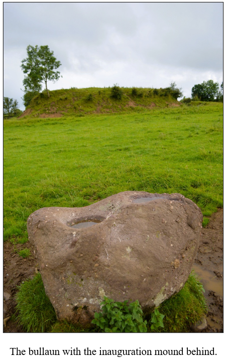
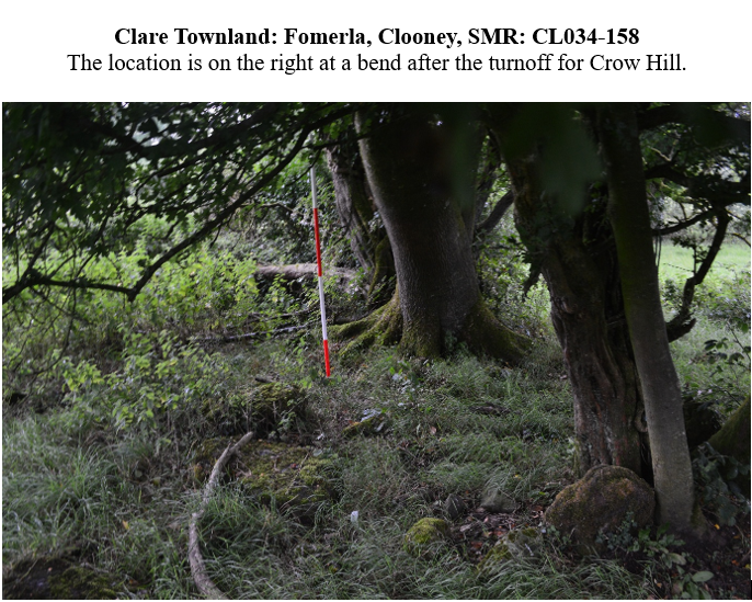
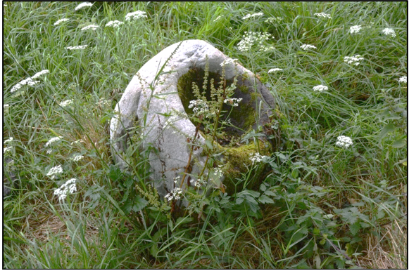
Large opening on bullaun stone, Fomerla townland, Tulla, CL034-158001
Cl. 21 (S) CL034-158 NGR: 14465, 17944 Stone Type: Sandstone Bas. no.: 1 L.: 77cm W.: 55cm T.: 42cm (max. vis.) Dm.: 34cm x 29cm Dp.: 15.5cm Dp. (low rim): na Dp. (high rim): na Dist. bas. st. edge: na Dist. bass.
Description: Irregularly shaped block of stone, apparently embedded only slightly in ground and, given its small size and the position of the basin (see below), probably not in situ. Carved in SE side of upper surface, which in this area slopes down steeply to SE, is a single, roughly pear- or D-shaped basin. If stone were tilted so that mouth of basin were approximately level, the latter would have a slight version of section with steep side diametrically opposed to shallow side; steep side of section would be to S (see section AB). In view of this, sections across basin have been recorded at right angles to basin rim, as if this were approximately level; the plan and dimensions of stone, however, have been recorded in the usual fashion (i.e., on a horizontal plane). Basin is ground quite smoothly; rim is well-defined, being clearest at SE. Context: Stone lies in a small, irregularly shaped cillín which is raised above surface of surrounding field. There is an earthen ringfort (CL034-040) c. 220m to NW (Westropp 1904a; SMR).
Context: According to SMR, stone is located at a ruined church c. 130m to S of a holy well (SMR).
*
Clare Townland: Kiltanon, Tulla, SMR: CL027-024
In the grounds of Kiltanon House as one approaches the Toomeen Caves
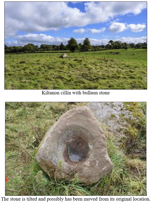
Cl. 37 (S) Fig. 75(ii) County: NGR: 14636, 18127 Stone Type: Sandstone Bas. no.: 1 L.: c. 77cm W.: c. 75cm T.: 60cm (max. vis.) Dm.: 34cm x 32.5cm Dp.: 12cm Dp. (low rim): na Dp. (high rim): na Dist. bas. st. edge: c. 10.5cm Dist. bass.:
Description: Roughly triangular boulder with single oval basin in flattish upper surface. When Westropp sketched stone towards end of 19th century, it rested on a flat stone slab (c. 130cm (max. vis.) x c. 90cm (max. vis.)); it has since then been shifted and leans at an angle with one end resting on N end of slab and the other on the ground to N of this. Stone is surveyed here as if flattish upper surface were approximately level, as it was in Westropp’s day. Basin is regularly ground but somewhat coarse textured; rim is sharply defined.
Context: Stone is located in a cillín represented by an irregularly shaped area of raised ground; Westropp notes that it is ‘near the only remaining block of a large cromlech’ but cites no evidence to support his identification of the structure as a cromlech (megalithic tomb) (Westropp 1898b, 547; 1904b, 111).