
Quin heritage site
Further information is provided here in support of the Visitor App recently launched by Quin Heritage Group. This information is provided courtesy of the National Monument Service online Map Viewer website. This will aid those seeking more detail than is appropriate for a generalised visitor narrative.
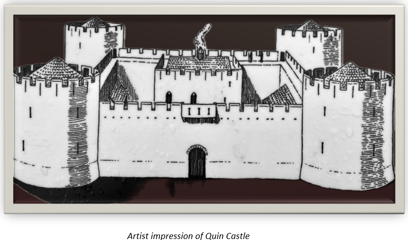
- Castle – Anglo-Norman masonry castle CL042-027001
Description: Situated on a bend of the River Rine at the NE edge of Quin village with some defence afforded by the river to the W and N. The ground falls away sharply towards the river to W and N. This Anglo-Norman castle was built in 1280 by Sir Thomas de Clare (c. 1245-87) in an attempt to subdue the Macnamaras. It was captured and burned by Cumheadha MacNamara in 1285 and in the 14th century much of it was demolished and used to build the Franciscan Friary (CL042-027002-) on the same footprint. Many of the castle walls were reused and incorporated into the Friary. (See Ua Cróinín 1997) for more on the history of the castle).
A substantial square castle (c. 37m across) with round corner bastions (ext. diam. 12m), the lower parts of which still remain at NE, SE and SW. Including the bastions the front elevation measures 48m. There are no above ground remains of a bastion at NW but there may have been one originally.
A deep wide flat-bottomed moat (dims. at SE: Wth at base 5.5m; Wth at top 15.3m; ext. D 1.24m; int. D 2.62m) is still evident from E to S. At S it is occupied by the present graveyard (CL042-027009-). Excavation (Hull 2017; Licence no. E004671) of the possible medieval school (CL042-027015-) to the E of the castle in 2017 revealed portion of the refilled moat at that location. Of the moat, Hull (2017, 15) states: ‘The excavation has established that the moat continued in a northward direction to the east of the monument although the full depth and width of the moat…was not established. It is very likely that the moat was constructed in parallel with the castle c. 1280 as the fourteenth century Caithréim Thoirdhealbhaigh (Hayes O’Grady 1929, 19) records “…knavish English belonging to the with-ditch-and-rampart-furnished castle of Quin…” and the Caithréim records also in 1285 that Quin Castle’s “…ditch was crossed, earthworks carried, great gate battered in and hewn down; its strong walls were breached, its English stammerers captured…” (ibid., 30). Given that the large rectangular structure targeted by Trench 1 was, in part, built over the moat and that a lead bullet that possibly dates to the first half of the seventeenth century was found in the construction cut for that building, then the moat was likely backfilled at the east of the castle/friary between the late thirteenth and late sixteenth centuries.’
The curtain walls survive best where they attach to the NE corner tower. The lower portion of the E end of the N curtain wall (Wth 2.9m; ext. H 1.52m) is still visible where it is attached to the tower. It is very low internally (H 0.25m) as the interior is raised to compensate for the sharp slope to the river towards the N. According to Ua Cróinín (1997) recent investigations have shown that much of the external kitchen wall of the Friary may also be contemporary with the castle.
The foundation of most of the E curtain wall survives (int. H 0.7m; ext. H 0.83m; Wth 2.87m) (original L between the corner towers 25.4m). It has a small low wall built on top (H 0.43m; Wth 0.38m) almost at the external edge and has a slight batter. The S end of the E curtain wall is now the E end of the Abbey church. The E window of the church has very deep splays due to the width of the wall. Close to the N end of E curtain wall there is a set of steps (Wth 1.07m) spiralling towards the top.
S curtain wall. This wall (Wth 2.75m) is substantially incorporated into the S wall of the Friary church (CL042-027002-) which was built along the same line. The main entrance to the castle was in the middle of the S wall and the inner arch of this (Wth 3.25m) is still present under the crossing tower of the Friary. The windows of the S wall of the church required deep splays both internally and externally due to the castle wall width giving them a strange external appearance.
The NE bastion (H 2.3m; diam. across the top 11.85m; int. diam. 4.56m; wall Wth 3.62m) is the best preserved and has a slight batter. It has a short entrance passage narrowing from 0.77m to 0.58m and has two deep rectangular internal recesses (Wth 2.68m) with deep widely splayed embrasures over (D 0.85-1.29m). A third recess (Wth 1.36m) has a flue narrowing towards the top.
The SE bastion is less well preserved (diam. at top 9.25m; ext. remaining H 3.32m; wall Wth 2.8m) as it joins what later became the SE corner of the Abbey church. It has two internal rectangular recesses (Wth 2.21-2.25m; D 1.7m).
The SW bastion, close to the entrance doorway to the Abbey is the least well preserved (diam 9.18m; ext. remaining H 2.14m; wall Wth c. 2m). The interior of this bastion has been built up and used for burial. Quin Castle and Friary are National Monuments in State Care, no. 15. (Westropp 1888, 334-5; Westropp 1900, 427-38; Ua Briain 1908; Ua Cróinín and Breen 1997; Hull 2017)
References:
Westropp, T.J. 1888 Notes on the Franciscan Abbey, Mainistir Cuinche, or Quin, Co. Clare. Journal of the Royal Society of Ireland 18, 334-5.
Westropp, T.J. 1900 Excursions of the Royal Society of Antiquaries of Ireland, Summer meeting, 1900. Description of the places visited. Alternative excursion. Journal of the Royal Society of Antiquaries of Ireland 10, 427-45.
Hull, G. 2017 Quin Friary, Quin, Co. Clare. Final Archaeological Excavation Report (licence no. E004671) Unpublished report submitted to the National Monuments Service, Department of Culture, Heritage and the Gaeltacht, Dublin.
Ua Briain, C. 1908 Parish of Quin. The Architectural and Topographical Record 1, part 2, 169-92.
Ua Cróinín, R. and Breen, M. 1997 The castles and tower-houses of Co. Clare, 6 vols. Unpublished report submitted to the National Monuments Service, Department of Culture, Heritage and the Gaeltacht, Dublin.
Hayes O’Grady, Standish (ed. & transl.) 1929 Caithréim Thoirdhealbhaigh by Seán (mac Ruaidhrí)
Mac Craith. London. Irish Texts Society.
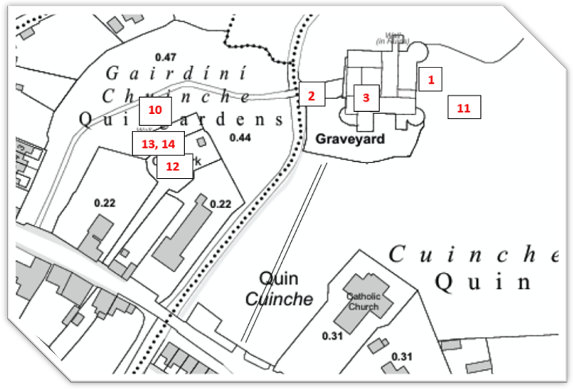
2. House – 17th century CL042-027021
Description: Situated on a sharp W-facing slope between the entrance doorway to Quin Abbey (CL042-027002-) (c. 8m to the E) and midway between it and the footbridge leading to St. Finghin’s Church (CL042-027003-). Only the complete S gable of the house remains (L 7.9m), all other walls are completely removed to ground level. The internal face has a large central fireplace (opening Wth 1.91m; H 1.31m) with a correspondingly wide chimneybreast narrowing in a stepped fashion as it rises. The fireplace and some of the chimneybreast have very recently been restored. A cupboard (Wth 0.5m; H 0.56m; D 0.43m) is immediately beside the fireplace to the W. The roof was steeply pitched and there are 2 small square windows in what would have been a gabled attic space. The wall is built of roughly coursed limestone becoming uncoursed towards the top. Just a few well-cut quoins remain externally at the W end. These are cut at a wider angle than 90 degrees implying that the W wall was angled away from the building. The house forms part of the N boundary of the graveyard and is likely to have been a guesthouse associated with the friary.
3. Religious house – Franciscan friary CL042-027002
Description: Situated on a W-facing slope on the E bank of the River Rine at the NE edge of Quin village, Quin Friary (known locally as Quin Abbey) is built on the burnt-out ruins of an Anglo-Norman de Clare castle (CL042-027001-). In 1280, the Anglo-Norman Sir Thomas de Clare commenced work on the castle at Quin. In c. 1285/7 Covea MacNamara stormed and burned the castle in revenge for the death of a chief named ‘O’Liddy “of the broad shield”’ and his brother. The remains of the earlier castle are still visible as they were incorporated into the friary, with the foundations of the rounded NE, SW and SE corner towers of the curtain wall surviving to varying degrees. The lower portions of the curtain wall adjacent to the NE tower also survive. No attempt was made to rebuild the fortress (Ua Cróinín 2014). Maccon Mac Conmara established a house at Quin for the Franciscan friars in 1433 having obtained a papal licence (McInerney 2014, 125). The friary was founded on an earlier house built by Síoda Cam Mac Conmara in 1402 (ibid.). Quin remained under the jurisdiction of the Conventuals until it was officially dissolved in 1541. The friars continued to live at Quin under the protection of the earls of Thomond. The abbey and lands were granted in 1543 to Conor O’Brien, Baron Ibracken, who, like all his family, protected the friars. Five years later – 1548, September 18 – it was granted to Teig M’Conor Brien and Tirlagh O’Brien of Dough. The friary became Observant when a community was reconstituted there in 1612 (Ó Clabaigh 2012, 66). Donatus Mooney, provincial of the Irish Franciscan province, visited in 1616 and noted Quin as ‘a singularly beautiful pile of building, such as is seldom met with in monastic establishments’ (O’Neill 2009, 320). The friars were forced to leave on a number of occasions in the seventeenth century but continued to return. They finally moved to Drim, some 2km distant where the last member of the community, Friar John Hogan, died in 1820. He was buried in the east ambulatory of the cloister. Despite its suppression and suffering repeated attack in the 16th century, substantial remains of the friary survive. The remains consist of a church at S with a transept added at the W end of the S wall and a sacristy N of the chancel. A cloister lies to the N with the dormitory, kitchen/refectory and chapter room arranged around it to the W, N and E respectively. The external walls of the W, N and E ranges have a significant base batter (H 3.65m) and the windows and door are recessed into it. The church (int. dims. 35.75m E-W; 7.1-7.15m N-S) comprises a nave and chancel with a tall slender crossing tower and belfry. The S and E walls are unusually wide (2.8m) as they utilise the foundations of the earlier castle. The SW corner of the church occupies the original corner of the keep. A small walkway in the SW corner of the church leads into the graveyard through a small passage (Wth 1.1m). A spiral stairs is accessed from this passage and leads to the roof. It is lit by two slit windows in the W wall face and two in the S. The external S wall face has the rough remnants of a bonded wall. Several external steps lead up to the main entrance at W (Wth 1.4m) which has a pointed door arch within a square frame richly worked with a series of narrow mouldings. A two-light lancet window is in the gable over the door. The N wall of the nave is plain except for a recess for a wall tomb at the E end covered by an ogee-headed arch and a small window into the cloister lighting a side altar. There is a stoup in the S wall of the nave just before the S transept. The basin is octagonal (diam. 0.52m; D 0.63m) and lies in a recess with a pointed arched and chamfered ope (H 0.97m; Wth 0.62m). There are triangular stop chamfers at each side of the ope, each slightly different. The recess is roofed with ribbed vaulting. A rectangular cupboard (Wth 0.5m; H 0.33m) occupies the top of the back wall of the recess and there are modern votive offerings around the basin. The S transept (11.95m N-S) is entered through a wide pointed arch (Wth 7.2m). It was added in the mid 15th century and the walls have more evenly coursed stonework than the nave. Its corners are flanked externally by buttresses diminishing in two stages and battered in the lower half. It is lit by two double-light windows at E over two side altars, one double light at W and a triple-light window at S with curvilinear tracery. A double piscina occupies the SE corner. A side altar, lit by a large two-light window with splayed ingoings, is at the E end of the nave adjacent to the crossing tower, matching the side altar on the N side. The crossing tower is in line with the original castle entrance, midway between the two rounded castle bastions. The inner portion of the round-arched castle entrance remains (Wth 3.25m; T 0.9m). It now leads into a small chamber within the wall, lit by a small round-headed window at S. The E side of the chamber is built up forming an altar. There are two wicker-centred arches under the N and S parts of the crossing tower and there are corbels at several different levels. The underside of the tower has one set of tierceron ribs and holes for the bell ropes are visible. Some examples of graffiti remain on the interior of the tower piers (Kearns 2015, 36-7). The tower itself has three levels, marked externally by string courses. The first floor has square openings towards the chancel and nave. It was approached from the roof of the dormitory at N but is not currently accessible. The second floor has one window at N lighting the stairs, the third or belfry level has large two-light ogee-headed windows at all sides except E where there is a smaller single window. The parapet has battlements at the corners with wide embrasures in between. There are two steps up into the chancel which is lit by two large windows in the S wall. That at E is two-light and that at W is three-light. Both are pointed with deeply splayed ingoings both internally and externally because of the thickness of the castle wall (T 2.8m). Externally, despite the use of arched voussoirs, the deeply set windows have an internal appearance. The E one has cutstone chamfered arch beneath the voussoirs giving it a more formal exterior. Ua Briain (1908) describes these windows as covered by ‘heavy arches’ giving a peculiar and characteristic appearance to the whole structure. A sedilia or tomb niche on the S wall of the chancel is surmounted by traces of an early 17th-century stucco crucifixion scene. This was sketched by Thomas Dineley in 1681. At that point the stucco work was more extensive and included paintings of two figures on the rear wall of the tomb niche (Ó Clabaigh 2012, 251-2). Some of the stucco work extends into the adjacent window splay to E and has incised decoration. The E castle wall was reconstructed to house the curvilinear triple-light E window resulting in a very wide curving splay as the window is set on the outside of the wide wall. The original high altar (Wth 3.5m) is still in place under the window. The gap between the base and the floor would have necessitated a wooden predella. The MacNamara (founder’s) tomb (CL041-027010-) is in the NE corner of the chancel and would have served as an ‘Easter Sepulchre’. A line of slightly raised rectangular slabs set into the floor separates the sanctuary from the rest of the chancel. A number of medieval graveslabs lie in the nave and chancel (CL042-027011-, CL042-027012-, and CL042-027016- to CL042-027020-). A gallery in the W end of the nave, evidenced by corbels, gave a privileged vantage point to guests staying in the west range of the friary (Ó Clabaigh 2012, 234). The sacristy (8.45m E-W; 3.5m N-S) is entered through a pointed chamfered doorway (Wth 1.04m; H 2m) in the N wall of the chancel. There are two decorative stop-chamfers at floor level, one with a fleur de lis. Inside the door there is a flat arch with wicker centring and slightly splayed ingoi
References:
Ua Cróinín, R. and Breen, M. 1997 The castles and tower-houses of Co. Clare, 6 vols. Unpublished report submitted to the National Monuments Service, Department of Culture, Heritage and the Gaeltacht, Dublin.
Ua Briain, C. 1908 Parish of Quin. The Architectural and Topographical Record 1, part 2, 169-92. Westropp, T.J. 1900 Excursions of the Royal Society of Antiquaries of Ireland, Summer meeting, 1900. Description of the places visited. Alternative excursion. Journal of the Royal Society of Antiquaries of Ireland 10, 427-45.
Ó Clabaigh, Colmán OSB 2012 The Friars in Ireland 1224-1540. Dublin. Four Courts Press. Westropp, T.J. 1888 Notes on the Franciscan Abbey, Mainistir Cuinche, or Quin, Co. Clare. Journal of the Royal Society of Ireland 18, 334-5.
Kearns, M. 2015 Quin Friary Graffiti. The Other Clare 39, 36-7. Deane, T.N. 1879-88 On Quin Abbey. Proceedings of the Royal Irish Academy, Series 2, vol. 2, 201-4.
O’Neill, M. 2009 Irish Franciscan friary architecture: late medieval and early modern. In E. Bhreathnach, J. MacMahon OFM and John McCafferty (eds.), The Irish Franciscans 1534-1990, 305-28. Dublin. Four Courts Press.
McInerney, L. 2014 Clerical and learned lineages of medieval Co. Clare: a survey of fifteenth-century papal registers. Dublin. Four Courts Press. Conlon, P. 1988 Franciscan Ireland. Dublin. The Lilliput Press.
Walsh, Fr. Paul Mary OFM 1959 The old friaries of Ennis and Quin. Wexford.
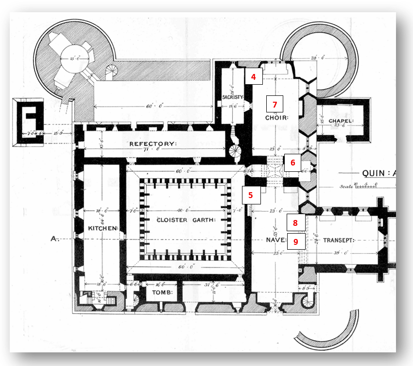
4. Wall monument CL042-027010
Description: A slender wall monument (Wth 2.4m; D 0.8m) occupies the NE corner of the chancel of Quin Abbey (CL042-027002-). A large slab with a moulded plinth is surmounted by a three-arched canopy with a widely spreading cornice supporting the great arch over the E window for most of its width. The arches are cusped and the spandrels are filled with well carved leaves in low relief. The cavetto or surround beneath the arch columns bears an inscription in raised gothic letters and is cited by Westropp (1892-4, 453) as follows: ‘Hic jacent Oid fili Laurencii [Lorcan] fili Mathi [Mahon] M com Ara et Constina M N Mara uxor Ej Q me fieri fecerut.’ An inscription on the front of the plain slab beneath is in capital letters and reads ‘Macnamara of Ayle. Died 1402’. A MacNamara armorial plaque is placed on the back wall under the canopy and a slab beneath it reads ‘This monument was erected by Mahon Daul McNemara, and repaired by Captain Teige McNemara of Ranna. A.D. 1714.’ (Ua Briain 1908)
References: Westropp, T.J. 1892-4 Quin Abbey. Journal of the Association for the Preservation of the Memorials of the Dead in Ireland 2, 453.
Ua Briain, C. 1908 Parish of Quin. The Architectural and Topographical Record 1, part 2, 169-92.
5. Graveslab CL042-027012
Description: Lying recumbent at the E end of the nave of Quin Abbey (CL042-027002-) adjacent to a side altar near the crossing tower. A limestone graveslab (L 0.9m; Wth 0.43m tapering to 0.23m at the top; D 0.07m). According to Westropp (1892-4, 279) the inscription in English reads ‘[Here lies the [body of] Donough [Macna] Mara of Ba…… who de[cease]d 1654.’ The slab is very weathered and is broken right across the middle in two places. Only a small portion of the inscription is legible.
6. Graveslab CL042-027016
Description: Situated under the S part of the belfry in Quin Abbey church (CL042-027002-). A large rectangular limestone graveslab (L 2.1m; Wth 0.75m; D 0.06m) oriented E-W. An inscription in English in raised Roman capitals extended around the entire edge but is very worn in places. The remaining legible part reads ‘THIS IS THE ANCIENT TUMBE OF ROBE (?)…’.
7. Graveslab CL042-027018
Description: Situated in the chancel of Quin Abbey church (CL042-027018-). A trapezoidal shaped graveslab oriented E-W and lying recumbent (L 1.3m; Wth at base 0.58m; Wth at mid-section 0.64m). The top left portion is broken away and there is no apparent inscription.
8. Graveslab CL042-027019
Description: Lying recumbent at the entrance to the S transept in Quin Abbey church (CL042-027002-). A trapezoidal shaped limestone graveslab (L 1.69m; Wth at base 0.57m; Wth at shoulder 0.48m narrowing to 0.19m at the top). The slab is broken irregularly across the middle. An incised carving of an axe is at the lower end. Westropp (1900, 438) notes that this is said to be the tomb of a carpenter killed by a fall from the roof in medieval times. A second slab (CL042-027020-) lies immediately to the E.
Reference: Westropp, T.J. 1900 Excursions of the Royal Society of Antiquaries of Ireland, Summer meeting, 1900. Description of the places visited. Alternative excursion. Journal of the Royal Society of Antiquaries of Ireland 10, 427-45.
9. Graveslab CL042-027020
Description: Situated at the entrance to the S transept of Quin Abbey church (CL042-027002-). A trapezoidal shaped limestone graveslab (L 1.19m; Wth at base 0.52m; max. remaining Wth 0.61m) with its top broken off and missing. The slab is oriented E-W and there is no evidence of an inscription. A second graveslab (CL042-027019-) lies immediately to the E.
10. Ecclesiastical enclosure CL042-027007
Description: Situated on generally level ground on the W bank of the River Rine with a slight slope to the E. Listed as earthwork complex in the SMR (1992) and the RMP (1996). Curving field boundaries on the 1840 OS 6-inch map show St. Finghin’s church (CL042-027003-) to be centred within a subcircular area (130m NE-SW; 100m NW-SE) with the River Rine completing the circle NE-S. Present field walls to the W and N retain this curve. A survey of earthworks in this area in 1982 (SMR file) concluded that some of them were the remains of modern structures and possibly natural ridges. It was noted that the area may be associated with the settlement (CL042-027—-) around Quin Abbey (CL042-027002-) on the E side of the river. Test trenching to the immediate N and E of St Finghin’s church (Carey 2003, 21, no. 89; Carey 2004, 51, no. 197; Licence no. 01E0573) uncovered disarticulated human bone and three skeletons oriented E-W indicating that the medieval graveyard also extended to this side. The line of a proposed pathway was altered on foot of this discovery. Several other trenches in the area produced no archaeological material.
References:
Carey, A. 2003 Quin Friary, Quin. In I. Bennett (ed.), Excavations 2001: summary accounts of archaeological excavations in Ireland, 21, No. 89. Dublin. Wordwell.
Carey, A. 2004 Quin Friary, Quin. In I. Bennett (ed.), Excavations 2002: summary accounts of archaeological excavations in Ireland, 51, No. 197. Dublin. Wordwell.
11. School CL042-027015
Description: Situated c. 18m E of Quin Friary (CL042-027002-). A rectangular structure (int. dims. c. 15.8m NE-SW; c. 12m NW-SE) known locally as ‘The School’. The feature is the largest of the many grassed over structures close to the remains of the Friary. A building orientated NE-SW is depicted at this location on the 1840 OS 6-inch map. When partially excavated (Hull 2017) the walls were found to partially overlie the back-filled moat of the Anglo-Norman castle (CL042-027001-). Remains comprise grassed-over stone walls (H. 1m; Wth 1.7-2.8m) with evidence of an entrance (Wth 3.4m) in the S wall near the SE corner. A possible 17th-century lead bullet was found in the construction cut. A school was founded c. AD 1643 by Eugene O’Cahan and was destroyed by Cromwellians in 1651. Antonius Broudinus, a Clare-born Franciscan noted that the school or studium had over 800 students in 1644 although this is likely to be an exaggeration (McInerney 2014, 204). Hull (2017) notes that the scale of the building compares well with the’ Cabhal Tighe Breac’ or O’Davoren school at Cahermacnaghten, Co. Clare (CL009-001009-).
References:
Hull, G. 2017 Quin Friary, Quin, Co. Clare. Final Archaeological Excavation Report (licence no. E004671) Unpublished report submitted to the National Monuments Service, Department of Culture, Heritage and the Gaeltacht, Dublin.
Hull, G. and McCooey, J. 2017 Archaeological excavation of earthworks at Quin Friary. The Other Clare 41, 51-9.
McInerney, L. 2014 Clerical and learned lineages of medieval Co. Clare: a survey of fifteenth-century papal registers. Dublin. Four Courts Press.
12. Graveyard CL042-027009
Description: Adjoining the S side of Quin Abbey (CL042-027002-) and bounded at W by the River Rine. Not listed in the SMR (1992) or the RMP (1996). A roughly rectangular graveyard (c. 64m E-W; c. 32m N-S) defined at S by a roughly coursed wall (H 0.88m; Wth 0.45m) with uprights cemented on top curving from W to E along the line of the castle moat (CL042-027001-) and at N by a short straight stretch of wall at NW adjoining the possible 17th-century guesthouse (CL042-027021-). A small gateway into the graveyard at S has some reused cut stone. Burials date mainly to the 19th and 20th centuries and the graveyard is still in use. Monitoring of groundworks undertaken in 2000 in advance of floodlighting the Abbey (Licence no. 00E0954) revealed disturbed human bone 1-2m outside the graveyard wall at S. (https://excavations.ie/report/2000/Clare/0004922/; accessed October 30, 2018).
13. Church CL042-027003
Description: On generally level ground with a slight slope to the E. The River Rine flows N-S at the base of the hill 50m to the E, in marshy terrain. There is a modern housing estate to the NW. Quin Abbey lies c. 80m to the E. There are fair-good views in all directions, though the views are impeded to the E by Quin Abbey, to the S by a house and to the W by a housing estate. Listed erroneously in the SMR (1992) and the RMP (1996) as being in Commons townland. A parish church dedicated to St. Finghin which was built c. 1278 by Thomas de Clare (Westropp 1900-2, 148; Anon. 1900, 439). The church is surrounded by a graveyard (CL042-027004-), though only the area S of the church is enclosed and evident as a graveyard. A possible ecclesiastical enclosure (CL042-027007-) is indicated on the 1840 OS 6-inch map. An undivided church (24m E-W; 8.2m N-S), built of roughly coursed limestone rubble. The NW angle has been rebuilt and the N wall does not survive. A later wall has been built roughly on the line of the N wall, possibly incorporating some of the original masonry at foundation level. Particularly large blocks of masonry have been used in the lower courses of the W gable, up to c. 4m. Externally a clasping buttress projects from the NE and SW angle and two angle buttresses from the SE angle. Though built of well-cut ashlar masonry, these buttresses appear to be contemporary with the original 13th-century church. The SE buttresses (total H c. 4.6m) have a battered base (H c. 3m) and are capped with sloping masonry (H c. 0.6m), with a projecting roll-moulding running along the top and a concave moulding along the base of the slope. The buttress at the NE angle is taller, less well preserved at the top and takes a different form from those at the SE angle, in that it is a clasping buttress which wraps around the NE angle. The buttress at the SW angle was modified in the 15th century when a bell-tower was built on this angle. The bell-tower forms a slender square tower which rises above the apex of the church. Externally there is a string-course below the two upper floors and it is capped by crenellations which rest on a projecting stone course. The top floor has a flat-headed single-light window in the W and E face and a flat-headed two-light window in the N and S face, though the mullion is gone from the N window. The floor below has a flat-headed single-light window in the W face. At the N end of the W gable inside the church there is a narrow doorway which gives access to a small square vaulted chamber (1.3m x 1.3m) at the base of the bell-tower. This chamber is lit by a flat-headed loop in the N wall. A narrow rectangular chute (Wth 0.22m; D 1.35m) runs through the overhead vault along the N wall and is the width of the chamber, its function was presumably to facilitate the bell rope(s). The upper levels of the bell-tower were accessed from a flat-headed doorway at the S end of the W gable just below roof level, presumably accessed from a wooden stair within the church. There are traces of external harling on the E gable which also has a number of put-log holes, particularly above window height. The church may originally have been entered through a W doorway, as disturbed masonry suggests there was a centrally placed doorway (H c. 2m; Wth c. 1.9m) in this gable. The surviving broken-out doorway, with hanging-eye and draw-bar hole, is at the W end of the S wall. The interior of the church was lit by a triple-light of graduated lancets in the E gable, two windows towards the E end of the S wall and a blocked up window at gallery level in the W gable. The westernmost window in the S wall is a pointed two-light, with external rebate and chamfer, and sandstone used in the easternmost window head. The stone at the base of the external masonry mullion (Wth 0.95m) is a reused chamfered window surround with mullion. The window closest to the altar is broken out, only the W side of the inner straight-sided embrasure survives. The large opening suggests that this was originally a two-light window. The W embrasure surround is moulded limestone, with a filleted roll-mould on the angle, flanked by a roll-mould on either side. The E window is flanked by two wall niches, a round-headed probable statue niche to the S and a slightly collapsed depressed arch niche to the N.
References:
Large, S. 2011 A church and graveyard survey in County Clare. Database and photographic record. Clare County Council. Clare Heritage Forum. The Heritage Council.
Westropp, T.J. 1900-02 The churches of Co. Clare and the origin of the ecclesiastical divisions in that county. Proceedings of the Royal Irish Academy, Series 3, vol. 6, 100-180.
Anon. 1900 Proceedings. Journal of the Royal Society of Antiquaries of Ireland, vol. 10, no. 4, 388-450.
14. Graveyard CL042-027004
Description: Situated on the SE side of St Finghin’s church (CL042-027003-) built c. 1278 by Thomas de Clare (Westropp 1900-2, 148). A roughly rectangular graveyard (39m NE-SW; 24m NW-SE) bounded by the church at NW and elsewhere by a modern stone wall. The external ground level is lower outside the graveyard wall at E (int. H 0.83m; ext. H 1.83m; Wth 0.65m). To S there is an even greater discrepancy in height (int. H 0.82m; ext. H 2.3m). Pre-development archaeological testing in 2008 (Licence no. E3921; Ruttle 2014, 12-18) located the probable original S boundary of the graveyard on the S side of this S wall at the lower level. Burials including skeletal remains of a person buried at the earliest in the 16th century were found in a roughly triangular area (10.2m x 8.9m x 7.3m). Boulders have been placed to mark the outline of the area and a plaque explaining this has been erected. Test trenching to the immediate N and E of St Finghin’s church (Carey 2003, 21, no. 89; Carey 2004, 51, no. 197; Licence no. 01E0573) uncovered disarticulated human bone and three skeletons oriented E-W. This may indicate that the medieval graveyard extended to this side. A curving field boundary to N and W c. 55m from the church, indicated on the OS 6-inch maps, shows St. Finghin’s church centrally placed between that and the river Rine to the SE and may indicate the outline of the medieval precinct (CL042-027007-). The present graveyard boundary contains mainly 19th and 20th century burials and there is a mausoleum commemorating the Spaight family at NE. A later church is depicted and named ‘St. Fineen’s Church within this graveyard on the OS 1st edition 6-inch map and on the later editions. According to Ruttle (2014, 16) this was a Protestant church built next to St Finghin’s in 1797. It was a small plain building with a low tower built by aid from the Board of First Fruits and was dismantled sometime after 1954 by the Board of Works. The church would have been attached to the S wall of the Spaight mausoleum and further remains are evident in the NE graveyard wall. The graveyard is accessed through a laneway at SW which originally lead directly to the later church.
References:
Ruttle, E. 2014 Investigations at St. Finghin’s Graveyard. The Other Clare 38, 12-18. Carey, A. 2004 Quin Friary, Quin. In I. Bennett (ed.), Excavations 2002: summary accounts of archaeological excavations in Ireland, 51, No. 197. Dublin. Wordwell.
Carey, A. 2003 Quin Friary, Quin. In I. Bennett (ed.), Excavations 2001: summary accounts of archaeological excavations in Ireland, 21, No. 89. Dublin. Wordwell.
Westropp, T.J. 1900-02 The churches of Co. Clare and the origin of the ecclesiastical divisions in that county. Proceedings of the Royal Irish Academy, Series 3, vol. 6, 100-180.
Large, S. 2011 A church and graveyard survey in County Clare. Database and photographic record. Clare County Council. Clare Heritage Forum. The Heritage Council.
Quin, Co. Clare – Descriptions of monuments at Quin from the Historic Environment Viewer, Department of Housing Local Government and Heritage https://heritagedata.maps.arcgis.com/apps/webappviewer/index.html?id=0c9eb9575b544081b0d296436d8f60f8